Easiest paths for walking and cycling; Combining syntactic and geographic analyses in studying walking and cycling mobility
10th Space Syntax Symposium, London, July 2015
Authors: Pirouz Nourian, Sevil Sariyildiz, Frank van der Hoeven
Abstract:
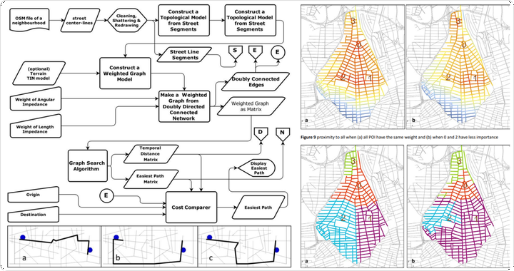
In this paper we discuss fundamentals of a new computational approach to configurative analysis and synthesis and present a number of advancements we have made in the direction of computational analysis of walking and cycling mobility. We have scrutinized the notion of distance and addressed it in correspondence with the notion of geodesic or optimum path. We present a new all-inclusive pathfinding algorithm for walking and cycling and show how this pathfinding algorithm can be used as a new basis for a number of conventional network indicators such as closeness and betweenness centrality measures-taking into account the physics of walking/cycling mobility as well as the cognitive aspect of human navigation. To this end, we revisit the meaning of distance and introduce a new notion of geodesic, which we call ‘easiest path’, i.e. a path that is reasonably short, flat and at the same time cognitively simple. Using this new geodesic, we reconstruct betweenness centrality indicator and introduce two new accessibility measures as ‘proximity to any’, ‘vicinity of all’ and a method of zoning as to walking and cycling accessibility. We show how suitability of locations as to their walking/cycling access can be modelled in a way that is immediately understandable for both citizens and urban designers/planners. Models are implemented as a toolkit, available as a freeware application..